Privacy and Personal Data Protection in Palestine: Double Violations and Absent Legislation - 7amleh - 2022
#Palestine #MassSurveillance #Data #privacy #DataProtection
#surveillance
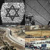
This report, conducted by Journalists Firas al Taweel and Buthaina Saffarini, sheds light on the issue of privacy and data protection in Palestine, examining the extent to which Palestinians’ privacy is respected and personal data protected, by the Palestinian Authority and telecommunications companies, internet providers, and digital payment companies, in the occupied Palestinian territory. It further investigates the relationship between private companies and Palestinian governmental bodies, and attempts to highlight how exposed Palestinians are, electronically and digitally, to the Israeli Authorities.#Palestine #MassSurveillance #Data #privacy #DataProtection
#surveillance
🇵🇸 UNOSAT Gaza Strip Agricultural Damage Assessment - November 2023
The decline in the health and density of the crops can be observed due to the impact of activities such as razing, heavy vehicle tracking, bombing, shelling, and other conflict-related dynamics. The analysis takes into account the damage that affects both active crop fields, fallow lands, and a multitude of household gardens. UNOSAT analysis shows that the agricultural extent in the Gaza Strip is estimated to be 185 sq. km, accounting for approximately 50% of the total area of Gaza. Compared to the average of the previous 6 years, approximately 15% of the arable land in the Gaza Strip has exhibited a significant decline in health and density in November 2023..
#Gaza #Agriculture #Maps #Satelite #UNOSAT #DATA
#Destruction #Desolation #Food
UNOSAT_GazaStrip_Agriculture_DA_GDB.zip
1.6 MB
UNOSAT Gaza Strip Agricultural Damage Assessment - November 2023
#Gaza #Report #Agriculture #Destruction #Satelite #Data
#UNOSAT
#Gaza #Report #Agriculture #Destruction #Satelite #Data
#UNOSAT