DJI Zenmuse P1 and Matrice 300 RTK التصوير بالطائرات الدرونز او المسيرة
احدث كاميرات واجهزة التصوير واكثرها كفاءة
احدث طائرات التصوير وافضلها ماتركس 300
تمتاز ب :
The P1 has a vertical accuracy of 5 cm and 3 cm horizontally
and can cover an area of 3 km during a single flight
full-frame sensor camera for photogrammetry and surveying.
The camera is capable of 45 MP still with 4.4-micrometer pixel size
the ability to take a photo every 0.7 seconds while in flight.
https://youtu.be/S_sLzNqxdNI
#الدرونز
#ِعبدالناصر_رشاش
#DJI #P1
تستخدم في المجالات التالية:
DJI recommends using the Zenmuse P1 for
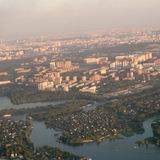
Topographical mapping,
cadastral surveying,
AEC and surveying,
natural resource management,
geological investigation,
disaster site modeling.
احدث كاميرات واجهزة التصوير واكثرها كفاءة
احدث طائرات التصوير وافضلها ماتركس 300
تمتاز ب :
The P1 has a vertical accuracy of 5 cm and 3 cm horizontally
and can cover an area of 3 km during a single flight
full-frame sensor camera for photogrammetry and surveying.
The camera is capable of 45 MP still with 4.4-micrometer pixel size
the ability to take a photo every 0.7 seconds while in flight.
https://youtu.be/S_sLzNqxdNI
#الدرونز
#ِعبدالناصر_رشاش
#DJI #P1
تستخدم في المجالات التالية:
DJI recommends using the Zenmuse P1 for
Topographical mapping,
cadastral surveying,
AEC and surveying,
natural resource management,
geological investigation,
disaster site modeling.