Forwarded from Make Europa Snow 🤍❄️🧬
White people!
Alone we're weak.
Together we're unbreakable, unstoppable & unconquerable. ✋🏻
NO MORE BROTHER WARS ⚡
Alone we're weak.
Together we're unbreakable, unstoppable & unconquerable. ✋🏻
NO MORE BROTHER WARS ⚡
Forwarded from Make Europa Snow 🤍❄️🧬
This media is not supported in your browser
VIEW IN TELEGRAM
Belarus new year ball dance 🇧🇾
How beautiful is this!
How beautiful is this!
Forwarded from Folk Wisdom & Ways
Iceland was largely, perhaps entirely, uninhabited when Norse colonisation started in the 9th c. AD, but after this the land filled up very rapidly. Already by the 10th c. Iceland had an established pattern of administrative organisation and a central assembly: the Alþing. The Alþing was established when the settlement period ended around 930 AD, and the earliest accounts of þing assemblies come from skaldic poetry (dating to 900-1400 AD), but the þing-system had been an Old Norse fixture for centuries prior.
Altogether, Iceland had 12 assembly districts, each featuring three þing assemblies where local þings were held to address local issues. Each þing was headed up by three godar (chieftains), who appointed bondar (free farmers) to act as judges. In 965 AD, Iceland was divided into a North, East, South, and West quarter, and the first of these received an additional þing. All cases that these could not handle were brought to the Alþing.
The Alþing convened once a year at Þingvellir (“assembly arena”) in southwestern Iceland, 40 km from the capital Reykjavík. According to written sources it lasted for two weeks, starting when 10 weeks of summer had passed. The Alþing was presided over by the Law Speaker but run by the lögrétta, the law council that held the legislative power in Iceland. The lögrétta was comprised of 146-147 þing-men who discussed, changed, and made new laws.
Only seven of the þing-sites mentioned in the sagas have been found, but there are many place-names throughout Iceland that feature the word ‘þing’ that are not mentioned in the sagas. Some of these also feature distinctive archaeological elements of such assembly places. Unfortunately, as it is problematic to date these sites it is hard to know if they were all in use at the same time or if some were founded later, explaining their absence in the literature.
All known þings are located near striking features in the landscape. Þingvellir itself seats near a lava crack that the river Silvrá runs through, a canyon (Almannagjá), a waterfall (Öxaráfoss), and several islands in the river running into Þingvallavatn—Iceland's largest lake.
Text: Anna Sunneborn Guðnadóttir. Copyright 2022 Scandinavian Archaeology.
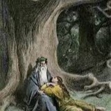
Images: Icelandic Alþing, W.G. Collingwood (1890s).
Altogether, Iceland had 12 assembly districts, each featuring three þing assemblies where local þings were held to address local issues. Each þing was headed up by three godar (chieftains), who appointed bondar (free farmers) to act as judges. In 965 AD, Iceland was divided into a North, East, South, and West quarter, and the first of these received an additional þing. All cases that these could not handle were brought to the Alþing.
The Alþing convened once a year at Þingvellir (“assembly arena”) in southwestern Iceland, 40 km from the capital Reykjavík. According to written sources it lasted for two weeks, starting when 10 weeks of summer had passed. The Alþing was presided over by the Law Speaker but run by the lögrétta, the law council that held the legislative power in Iceland. The lögrétta was comprised of 146-147 þing-men who discussed, changed, and made new laws.
Only seven of the þing-sites mentioned in the sagas have been found, but there are many place-names throughout Iceland that feature the word ‘þing’ that are not mentioned in the sagas. Some of these also feature distinctive archaeological elements of such assembly places. Unfortunately, as it is problematic to date these sites it is hard to know if they were all in use at the same time or if some were founded later, explaining their absence in the literature.
All known þings are located near striking features in the landscape. Þingvellir itself seats near a lava crack that the river Silvrá runs through, a canyon (Almannagjá), a waterfall (Öxaráfoss), and several islands in the river running into Þingvallavatn—Iceland's largest lake.
Text: Anna Sunneborn Guðnadóttir. Copyright 2022 Scandinavian Archaeology.
Images: Icelandic Alþing, W.G. Collingwood (1890s).