Forwarded from SHALIN ✙
| Написати нам | Зарядити канал | Твіттер | Підтримка |
Please open Telegram to view this post
VIEW IN TELEGRAM
Please open Telegram to view this post
VIEW IN TELEGRAM
❤2🤔2🤣2🤬1
Forwarded from SHALIN ✙
Столиця ворога готується до «свята» в умовах тотального страху. Ситуація в центрі Москви більше нагадує облогу, ніж підготовку до параду.
• Блокпости: На в'їздах до Москви розгорнуто контрольно-пропускні пункти.
• Бронетехніка: Біля Кремля помічено броньовані машини та позашляховики з кулеметними установками.
• Снайперські позиції: На всіх вежах, стінах та будівлях Кремля розосереджені бійці спецпідрозділів. Окрім снайперських гвинтівок, вони оснащені кулеметами та засобами РЕБ/стеження.
• Схованки: Навіть на Спаській вежі «замаскували» вогневу точку з кулеметником.
Червона площа повністю перекрита. Окупанти явно нервують через можливі «сюрпризи» з повітря та не тільки.
| Написати нам | Зарядити канал | Твіттер | Підтримка |
Please open Telegram to view this post
VIEW IN TELEGRAM
Please open Telegram to view this post
VIEW IN TELEGRAM
❤3🤡2👍1🤔1
Forwarded from ✙DeepState✙🇺🇦
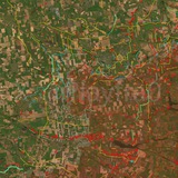
🚧 У регіоні активно розбудовується багаторівнева система фортифікацій. Паралельно створюються інженерні загородження та розвивається мережа рокадних доріг, що дозволяє підвищити мобільність підрозділів і забезпечити швидке перекидання сил у разі потреби.
Мапа
Please open Telegram to view this post
VIEW IN TELEGRAM
🤔3🤡2
Forwarded from Фенікс
This media is not supported in your browser
VIEW IN TELEGRAM
Пілоти прикордонного підрозділу “Фенікс” фіксують чергові воєнні злочини загарбників у Костянтинівці. Наша аеророзвідка змогла засняти, як ворог атакував місто важкими авіабомбами просто серед ночі. Під прицілом — житлові квартали багатостраждального міста.
Підтримай канал бустом
Вакансії | Банка | Facebook | TikTok | YouTube | Instagram
Please open Telegram to view this post
VIEW IN TELEGRAM
😁3🤔3👎2❤1
Forwarded from 155 омбр ім. Анни Київської
Media is too big
VIEW IN TELEGRAM
ЯК ТЕПЛОВІЗОР ПІЛОТА ЗНАХОДИТЬ ШТУРМОВИКІВ В "ЗЕЛЕНЦІ"?
Тепло ворога — мішень!
Ворог думає, що посадка чи трава — це "зелена фортеця".
Але дивіться, як крізь листя та гілки проступає інфрачервоний "тепловий слід".
Далі треба лише "видалити зайве".
Тепло ворога — мішень!
Ворог думає, що посадка чи трава — це "зелена фортеця".
Але дивіться, як крізь листя та гілки проступає інфрачервоний "тепловий слід".
Далі треба лише "видалити зайве".
👍5❤2
Rodynske, Bilytske, Kostyantynivka and Kupyansk, April 2026.
😢12😁4🎃1
🇺🇦🇷🇺 A bit more than a year passed after Ukraine made a risky bet on a new and modern type of fortification, that is, a series of engineering obstacles, and it is interesting to summarize and analyze from different perspectives what was accomplished in this time.
- From a strategy point of view, a major switch from trench building to obstacle digging happened. Up to 2024 Ukraine prioritized building lines of defenses that were characterized by large trench systems; now the actual "defensive line" is the ditches and barbed wire and tripwire in front of them, which significantly aid the FPV kill zone.
Small but sturdy trench systems are built just behind those obstacles.
- Regarding trenches specifically, the preferred digging method is now the following: Dig a ~2 meter deep trench on the side of a treeline, then cover it with a metal frame, sturdy roofing, and packed dirt on top of it. Very small holes covered by anti-drone metal frames are left in case it's necessary to engage in a fire battle.
This way, Russian FPVs are forced to brute-force a very small opening on the top part of the trench by consistently hitting it with precision, thus really compromising only one section of the trench system.
Some systems are even equipped with fire extinguishers and backup building materials to attempt field repairs of the trench.
Airstrikes and artillery strikes have a larger, but not catastrophic, effect on them: looking at real examples, a number of systems built even in early 2025 still more or less have their roofing intact.
- Strategically, the Ukrainians bet on an interesting digging order of defensive lines: in early and mid-2025, they focused on strongly reinforcing areas closer to the front line, and from then, they redirected resources to digging in the relative rear.
After that, they started to build defensive lines in between, and the process repeats.
By not digging while retreating, a defensive line is always ready in case of an unexpected breakthrough.
- Functionally, the main catalysts of the new defense system are a large number of Ukrainian FPVs and recon drones.
The recon drones constantly conduct surveillance over engineering obstacles, like rows of ditches and barbed wire (if necessary, focusing on chokepoints created on purpose as "traps", often located near highways and roads).
The engineering obstacle itself slows the Russian infiltration attempt down significantly, which gives time to the responsible FPV crews to fly and eliminate the threat while they themselves take cover in the sturdy trenches behind the obstacles together with the infantry, which at need engages in contact battles.
- In general, I am satisfied by the pace and strategy with which the Ukrainian engineering forces are currently fortifying the country.
Russian forces are unable to keep up with the rate of creation of new defensive lines (that is, by the time they would cross a line, at least a new one would be finished), and this creates a "strategic headache" for the Russians, which only time will tell how they will attempt to solve.
For the first time since 2023-2024, I wouldn't mind saying that the Zaporizhzhia, Dnipropetrovsk, and Donetsk Oblasts are more or less adequately prepared for a possible significantly prolonged war.
Specifically, there are still weak zones and a number of problems to solve, but the general picture doesn't look bad.
❤13🙏2😴2👍1🤡1
🇺🇦 Шановній Бійці! Якщо ви зараз перебуваєте у напрямку Часова Яра, Гуляйполя, Покровська, Новопавлівки, Лимана, Сіверська, Куп'янська або Сум, будь ласка, зв'яжіться зі мною особисто в Telegram (@Playfra) або в Signal чи WhatsApp (передам особисто).
Дякую!
Дякую!
👍5❤1🤣1
🗺 Some more of my personal thoughts about the situation, specifically about current problems in mapping work and the role of geolocations in mapping.
A short introduction to the root of the problem.
It is no secret to all mappers and many followers of the Ukraine War that mapping in 2025-2026 has now become much more difficult because of drone warfare, which has as consequences both sides' infiltration tactics (especially Russia's) and a chaotic "front line" made up of small individual positions because of the impossibility of concentrating too much manpower in one single spot (which makes infiltrations easier).
Once more, because of the prevalence of drones, the battlefield is being recorded 24/7, and strike-recon work is now being viewed as routine by soldiers on both sides.
This has the effect of having more net material to publish but less that is actually published (since it's "not as exciting" and "routine").
At the moment, public footage constitutes ~5-15% of what really happens at the front depending on the unit.
As such, many mappers, not being able to follow a single reliable source, edit their maps based on geolocations, objective data that, as said, represents a very small fraction of what really happens, this way doing so incorrectly, and often even drawing conclusions based on the same incomplete data.
A false sense of dynamicity is also often created, which (mind you, not always) often doesn't exist in the field.
Let me explain myself better with an example.
- In late April, Russian forces were hit by Ukrainian FPVs in Novoselivka, Huljajpole direction, quite far between the "contact line" most maps have drawn (original geolocation: https://t.me/creamy_caprice/11759).
Most mappers, seeing this, understandably think that if Russian forces were hit there, that territory must be under their control.
This thought process, though, is almost always fundamentally incorrect when talking about either side's advancements.
Depending on the specific map's criteria and, by now, conventionally, it's necessary for the side in question to do the following:
- consolidation of their positions, a key and often time-intensive part of battles, to draw a red zone, and
- frequency in their infiltrations to draw a gray zone (with rarer situations where a no man's land appears, which is conventionally represented in gray).
Since geolocations are only a "snapshot" of what's really happening, we can't make out any context at all that is required to fulfill any of the two conditions in case a mapper wants to draw anything, so it follows that it's incorrect to make any conclusions whatsoever based on geolocations alone.
Applying this logic to the Novoselivka example, it is as such not possible to accurately predict whether a gray zone, a red zone, or a lack of changes is correct to map in the eastern part of the village because it's not possible to know the context required for the two abovementioned conditions in the first place.
(For completeness purposes, the "answer" for the Novoselivka problem is that it's incorrect to draw a gray or red zone in the first place, as Russian infiltrations into the village are still not frequent but rather sporadic, and even less so is there consolidation).
Let's look at an additional example: the dozens of Russian flags in Huljajpole some months ago or the flag war in Dachne, Novopavlivka direction.
In this case, we're dealing with flags.
Because most of the general public takes flags as proof of control, and mappers take them as geolocations, just like strikes on infantry, airstrikes, or shellings, both sides of the war continue to organize such PR stunts to gather media attention for their own purposes because they, very simply, work.
Practically, in both cases, to wave or place the flags down, an infiltration into the objective had to happen and then, usually, an exfiltration to friendly lines or, more rarely, an attempt to hold the new positions.
👍3🤡3❤2🤔1
In neither course of events do we have consolidation nor infiltration frequency (statistically looking at past examples and admissions from both sides of this PR strategy), which makes drawing anything based on flags also incorrect.
Logically and methodically, we arrived at a point where it's clear why geolocations are not as useful as almost everybody considers them to be.
What can one make of this thread? If you're not interested in the specifics of mapping, other than ignoring flags, almost nothing: it's not like this will change the course of the war.
If you are, I would suggest devaluing geolocations as secondary in your mind and starting to make up your own mind on people or groups of people that claim to have information different from geolocations.
Are geolocations totally useless? No, they are crucial for archive work, and they often provide interesting footage over a certain area, as well as possible proof of claims.
Should they be a core part of mapping? In my opinion, since early 2025, no.
All of what I said is completely made up of personal opinions based on my experience as a follower and mapper of the Ukraine war, so feel totally free to comment with objections, proof, or thoughts regarding my logic!
👍2🤔2🤡1👀1
Forwarded from Apachi | STRIKE GROUP
ПОБЄДОБЄСІЄ, або Населений пункт в кредит
російська пропаганда знову намагається видати бажане за дійсне, та набиває собі нагород перед «днем перемоги».
У мережі поширюють зрежисоване відео про нібито «перехід на бік ворога» воїнів 81-ої ОАеМБр
Це відверта брехня та провокація.
Чому це фейк?
1.📍 Невідповідність погоди: На відео окупантів навколо зруйнованої будівлі лежить сніг. Проте на актуальних кадрах нашої розвідки (див. фото праворуч) чітко видно реальний стан місцевості та відсутність снігу.
2.🎬 Штучна анімація: Рухи «персонажів» на відео виглядають неприродно. Це вказує на використання ШІ для оживлення старих зимових фотографій.
3.🛡 Контроль ситуації: Станом на зараз у Піскунівці немає жодних «перебіжчиків» чи підрозділів армії рф. Наші десантники надійно тримають позиції.
Все це мрії ворога, та спроби вислужитися заради нагород перед диктатором напередодні «дня перемоги»
Закликаємо вас не ведіться на дешеві трюки ворожих ЗМІ. Окупант намагається посіяти зневіру, коли не може перемогти на полі бою.
Слава Україні! 🇺🇦
🐳6🤡3🌚1