Playfra - Maps & Analyses
New Ukrainian fortifications built in the last 3 days. Yellow: ditches (+4.5 km) Blue: dragon's teeth (+0 km) Gray: barbed wire (+22.5 km) *The maps shown do not in any way break OPSEC or represent sensitive data. Everything that was mapped was done using…
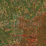
New Ukrainian fortifications built in the last 10 days.
Trenches: +22 trench systems
Ditches: 185.8 km
Dragon's teeth: +0 km
Barbed wire: +100.4 km
Yellow: ditches
Blue: dragon's teeth
Gray: barbed wire
*The maps shown do not in any way break OPSEC or represent sensitive data. Everything that was mapped was done using public sources, and both sides know well about what is shown in these maps.
❤7👍3🙏2🤔1
Forwarded from Тарас Григорович повідомляє
This media is not supported in your browser
VIEW IN TELEGRAM
Наразі встановлюється його тип, походження та можливий маршрут.
Please open Telegram to view this post
VIEW IN TELEGRAM
🤔4🤣4🌚2🔥1😎1
Forwarded from Інформаційний простір України
🫠Молдова наступна? російський Шахед перелетів молдавський кордон – дронова загроза триває для сусідів.
ㅤ
Інформаційний простір України
ㅤ
Інформаційний простір України
🔥5🤔5
Forwarded from DIVGEN 🚩 Карта СВО
Ребятам из Дома осинтеров подогнали эксклюзив уничтожения дамбы под Славянском.
➖ ➖ ➖ ➖ ➖
Сегодня Вооружёнными Силами ВС РФ была разрушена дамба в н.п. Райгородок.
📌
#удары
🇷🇺 @divgen | 🌐 divgen.ru
Сегодня Вооружёнными Силами ВС РФ была разрушена дамба в н.п. Райгородок.
48.915081, 37.752093#удары
Please open Telegram to view this post
VIEW IN TELEGRAM
Please open Telegram to view this post
VIEW IN TELEGRAM
🤬13🔥5👏3❤1😭1
Novopavlivka direction.
In the last weeks and months, Russian forces consolidated their positions in Zelenyi Hai and have been attacking Ivanivka, especially from there, other than from the fields between Ivanivka and Filiya.
The built ditches and barbed wire, and the Vovcha River especially, have somewhat saved the situation and constitute barriers that are very difficult for the Russians to pass: Ivanivka would've been long lost if it wasn't for them.
In Novopavlivka itself, over the past months after the Russian mechanized attack, Ukrainian forces gradually cleared and recaptured some positions in the center-south of the settlement, but the southern part continues to remain a gray zone, with frequent Russian infiltrations coming especially from Filiya, sometimes going quite deep, although without consolidation.
Unfortunately, there have been instances (but that's by now a more or less common occurrence) of unreal tasks being set by the higher command in this specific direction: I can only hope that this won't repeat and that the command won't go forward with their plans.
🤔3🤡2❤1👍1
Forwarded from Офіцер
Дороги до Донбасу - то настільки болюча тема, що вже просто біля тих нещасних «доріг» в сусідніх полях зʼявляються цілі розвʼязки, по яким ним реально зручніше пересуватися.
Їдеш і не можеш зрозуміти якою ж дорогою везли туди нещодавно президента, якщо там всюди прям срака)
Офіцер ✙ | Підписатись
Їдеш і не можеш зрозуміти якою ж дорогою везли туди нещодавно президента, якщо там всюди прям срака)
Офіцер ✙ | Підписатись
😢6❤4🤣4🐳3
Forwarded from Політстор
🇱🇹 🇺🇦 Дрон, що розбився в Литві, виявився українським — Bloomberg
Прем'єр країни повідомив, що літальний об'єкт, який упав у понеділок на півдні Литви, — це український БпЛА. Він мав атакувати цілі в Росії, проте впав на території союзника.
Прем'єр країни повідомив, що літальний об'єкт, який упав у понеділок на півдні Литви, — це український БпЛА. Він мав атакувати цілі в Росії, проте впав на території союзника.
😁15🤔4
High combat activity today in the Sopych area, Sumy Oblast'.
🤔8🔥2❤1🤬1
Playfra - Maps & Analyses
High combat activity today in the Sopych area, Sumy Oblast'.
The whole northern border was quite active, too, apparently.
🤔6🔥3🤯1
High combat activity in the last 24 hours in Hryshyne, Rodynske and Fedorivka Druha (Pokrovsk and Siversk directions).
🤔5
Kostyantynivka. Clarified the situation in the city, specifically regarding the geolocation of the Ukrainian destruction of part of an industrial building practically in the city center.
The action was a one-time infiltration action, without consolidation, and it came from the southeast, going through the Kazenyi Torets river valley and forests, which are a convenient route for movements.
This is a more or less known weak point, but it should definitely be paid attention to.
The action was a one-time infiltration action, without consolidation, and it came from the southeast, going through the Kazenyi Torets river valley and forests, which are a convenient route for movements.
This is a more or less known weak point, but it should definitely be paid attention to.
🤡8👍7🤔3🤣2😁1
Kostyantynivka. More in detail about the last couple of days.
Arrows are all red: no Russian attack has been successful lately.
In general, the sector is quite hot, and Ukrainian barrel artillery has been working hard lately, even almost all day when the weather is clear. Lately, shots can be heard every 3-5 seconds, which is an extremely high frequency and seems to hint at the fact that the Ukrainians have stockpiled a lot of shells.
Arrow 1: Russian infantry movement along the Kleban-Byk reservoir's forests, then along a treeline leading to Berestok, stopping there and continuing further to the junction between Illinivka and Kostyantynivka, where their attack was finally repelled by Ukrainian drones.
Arrow 2: Russian infantry movement along the Kleban-Byk reservoir's forests, then along two treelines ending in a creek that leads to Kostyantynivka's garbage dump. The Russians were stopped by Ukrainian drones just before the creek.
Arrow 3: Russian infantry movement along the railway and treelines near the Kazenyi Torets river, avoiding Pleshchiivka up to its northern edge, where the attack was repelled by Ukrainian drones.
Arrow 4: Russian infantry movement along the railway line, repelled just before the start of Kostyantynivka by Ukrainian drones.
Arrow 5: Russian infantry attack through the "Yahidka" dachas, with heavy casualties, repelled by Ukrainian drones and small arms fire in the dachas themselves and at the start of Kostyantynivka's southeastern edge.
Arrow 6: Russian infantry attack jumping through the fields, bushes, and foxholes, repelled by Ukrainian drones just before the Santurynivka district.
Arrow 7: Russian infantry attack along the main highway, then into the forest up to the pond, repelled with heavy casualties by Ukrainian drones.
Observation: Russian forces are present in Berestok, and continue to sometimes be detected and destroyed in the Ukrainskiy Khutir district. The Russians did not consolidate their positions in Kostyantynivka's center. Some Russians were also spotted and destroyed near the railway bridge at Santurynivka.
👍7🤡7🤔2
Some observations and updates about the Ternuvate sector.
Lately, I saw the situation stirred up a lot of talk online, so I'll write something to clear some things up.
1. Ternuvate is absolutely under Ukrainian control, and any information affirming the opposite does not correspond to reality.
Ukrainian rear services continue to be stationed there, a big number of Ukrainian infantry is also there, and cars continue to pass inside the settlement with acceptable safety.
Russian forces, though, after having been pushed out and cleared in early February after their initial infiltrations (https://t.me/PlayfraOSINT/3857), lately have started to renew attempts to reach Ternuvate again.
They walk by foot for long distances but often don't have success in reaching Ternuvate itself and are stopped earlier, but nonetheless, as evidenced by https://t.me/DeepStateUA/23325, sometimes they make it to Ternuvate: along the way, they are significantly hindered by the Ukrainian FPV kill zone set up in the fields east of Dobropillia, in the settlement itself, by the Haichur River and its swamp, by the two barbed wire lines and the ditch, and then by Kosivtseve itself, which has conserved for all this time a good number of Ukrainian positions.
It's also worth saying that Ukrainian forces conduct regular and organized sweeps of Ternuvate, something like they had done for a long time, effectively, in Stepnohirsk, so I don't find it likely that the situation will significantly worsen in the near future.
2. Dobropillia and Varvarivka. Not a lot of stable Russian positions. The gray zone is more caused by infiltrations and not as much by Russian presence itself.
Russian attacks, usually once every 2-3 days, are recorded with infantry and sometimes motorcycles coming from the horizontal ravines (this morning, for example), mostly unsuccessful because of the good level of organization the Ukrainians managed to reach, which led to the creation of an FPV kill zone.
The infiltration group is usually eliminated within 2 days.
At the moment the situation isn't critical, even though pressure is high.
3. Solodke and Rivnopillya. Work continues to be conducted, as evidenced by already public geolocations. I have talked about this since early February, and since then a slow eastward movement and consolidation have been ongoing.
👍14🤡7🤔1🖕1💊1
Playfra - Maps & Analyses
Ukrainian barrel artillery has been working hard lately, even almost all day when the weather is clear. Lately, shots can be heard every 3-5 seconds, which is an extremely high frequency and seems to hint at the fact that the Ukrainians have stockpiled a lot of shells.
Audio
Kostyantynivka ambience. An example of an outgoing Ukrainian shell heard from far away
❤1🤔1
Forwarded from WarArchive
This media is not supported in your browser
VIEW IN TELEGRAM
🇺🇦 Опис: Пасажири цивільного автомобіля, за фільмували посадку трьох гелікоптерів Мі-8, які прилетіли у місто для медичної евакуації. Вони забрали поранених і одразу вилетіли назад. Місто Маріуполь, Донецька обл.
🇬🇧 Description: Passengers in a civilian vehicle filmed the landing of three Mi-8 helicopters that had flown into the city for a medical evacuation. They picked up the wounded and immediately flew back. Mariupol, Donetsk Oblast.
❗️ This is a rather unique video that sheds light on a little-known fact. There’s very little information online about these events, and even this small piece of information is quite hard to find if you don’t know what to type into the search bar. Unfortunately, the video has reached us in low quality, but the main thing is that it exists at all.
WarArchive
Please open Telegram to view this post
VIEW IN TELEGRAM
❤6😁1🤔1
Forwarded from WarArchive
Фото №1 — 47.099986,37.593455
Фото №2 — 47.108983,37.625792
Фото №3 — 47.065781,37.503161
🇺🇦 Опис: Супутникові знімки від компанії Maxar, що показують оточене місто в доволі не поганій роздільній здатності. Місто Маріуполь, Донецька обл.
🇬🇧 Description: Satellite images from Maxar showing the besieged city in fairly good resolution. The city of Mariupol, Donetsk Oblast.
WarArchive
Please open Telegram to view this post
VIEW IN TELEGRAM
Please open Telegram to view this post
VIEW IN TELEGRAM
😢4❤2